|
|
|||||||||||||||||
| Point ID: 8910 | Downloads | Plots | Site Data | Code: 70573 |
|
|
|||||||||||||||||
| Download | |
|---|---|
| Site Descriptor Information | Site Time Series Data |
| Link to all available data | |
| View: | Time Series | All |
| Units: | mm |
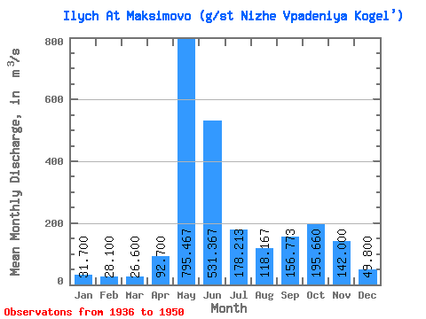
| Statistic | Jan | Feb | Mar | Apr | May | Jun | Jul | Aug | Sep | Oct | Nov | Dec | Annual |
|---|---|---|---|---|---|---|---|---|---|---|---|---|---|
| Mean | 31.70 | 28.10 | 26.60 | 92.70 | 795.47 | 531.37 | 178.21 | 118.17 | 156.77 | 195.66 | 142.00 | 49.80 | 180.79 |
| Standard Deviation | 69.72 | 234.67 | 239.78 | 102.24 | 78.89 | 83.29 | 91.75 | 7.07 | |||||
| Min | 31.70 | 28.10 | 26.60 | 43.40 | 444.00 | 94.50 | 73.20 | 43.40 | 63.30 | 57.80 | 137.00 | 49.80 | 180.79 |
| Max | 31.70 | 28.10 | 26.60 | 142.00 | 1310.00 | 1010.00 | 522.00 | 325.00 | 325.00 | 334.00 | 147.00 | 49.80 | 180.79 |
| Coefficient of Variation | 0.75 | 0.29 | 0.45 | 0.57 | 0.67 | 0.53 | 0.47 | 0.05 |
 Return to R-Arctic Net Home Page