|
|
|||||||||||||||||
| Point ID: 8910 | Downloads | Plots | Site Data | Code: 70573 |
|
|
|||||||||||||||||
| Download | |
|---|---|
| Site Descriptor Information | Site Time Series Data |
| Link to all available data | |
| View: | Time Series | All |
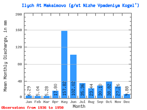
| Units: | m3/s |
| Statistic | Jan | Feb | Mar | Apr | May | Jun | Jul | Aug | Sep | Oct | Nov | Dec | Annual |
|---|---|---|---|---|---|---|---|---|---|---|---|---|---|
| Mean | 6.29 | 5.08 | 5.28 | 17.80 | 157.80 | 102.02 | 35.35 | 23.44 | 30.10 | 38.81 | 27.26 | 9.88 | 422.65 |
| Standard Deviation | 13.39 | 46.55 | 46.04 | 20.28 | 15.65 | 15.99 | 18.20 | 1.36 | |||||
| Min | 6.29 | 5.08 | 5.28 | 8.33 | 88.08 | 18.14 | 14.52 | 8.61 | 12.15 | 11.47 | 26.30 | 9.88 | 422.65 |
| Max | 6.29 | 5.08 | 5.28 | 27.26 | 259.87 | 193.92 | 103.55 | 64.47 | 62.40 | 66.26 | 28.22 | 9.88 | 422.65 |
| Coefficient of Variation | 0.75 | 0.29 | 0.45 | 0.57 | 0.67 | 0.53 | 0.47 | 0.05 |
 Return to R-Arctic Net Home Page