|
|
|||||||||||||||||
| Point ID: 8905 | Downloads | Plots | Site Data | Code: 70566 |
|
|
|||||||||||||||||
| Download | |
|---|---|
| Site Descriptor Information | Site Time Series Data |
| Link to all available data | |
| View: | Time Series | All |
| Units: | mm |
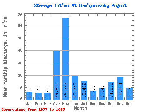
| Statistic | Jan | Feb | Mar | Apr | May | Jun | Jul | Aug | Sep | Oct | Nov | Dec | Annual |
|---|---|---|---|---|---|---|---|---|---|---|---|---|---|
| Mean | 6.09 | 5.32 | 5.29 | 39.57 | 66.26 | 20.29 | 15.48 | 7.49 | 9.34 | 14.84 | 18.21 | 9.78 | 18.46 |
| Standard Deviation | 3.06 | 3.23 | 3.26 | 27.83 | 35.01 | 18.33 | 13.76 | 9.96 | 8.19 | 8.17 | 9.56 | 5.13 | 3.93 |
| Min | 2.46 | 1.70 | 2.15 | 8.67 | 10.30 | 4.93 | 1.41 | 1.54 | 2.82 | 5.65 | 6.60 | 4.22 | 15.74 |
| Max | 11.00 | 11.40 | 10.60 | 92.70 | 118.00 | 62.60 | 36.10 | 33.60 | 26.70 | 31.20 | 35.30 | 18.80 | 27.98 |
| Coefficient of Variation | 0.50 | 0.61 | 0.62 | 0.70 | 0.53 | 0.90 | 0.89 | 1.33 | 0.88 | 0.55 | 0.53 | 0.53 | 0.21 |
 Return to R-Arctic Net Home Page