|
|
|||||||||||||||||
| Point ID: 8905 | Downloads | Plots | Site Data | Code: 70566 |
|
|
|||||||||||||||||
| Download | |
|---|---|
| Site Descriptor Information | Site Time Series Data |
| Link to all available data | |
| View: | Time Series | All |
| Units: | m3/s |
| Statistic | Jan | Feb | Mar | Apr | May | Jun | Jul | Aug | Sep | Oct | Nov | Dec | Annual |
|---|---|---|---|---|---|---|---|---|---|---|---|---|---|
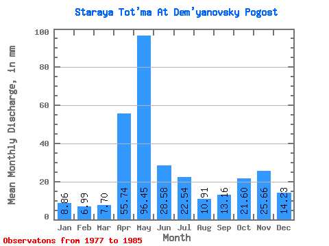
| Mean | 8.86 | 7.05 | 7.70 | 55.74 | 96.44 | 28.58 | 22.53 | 10.91 | 13.16 | 21.59 | 25.66 | 14.23 | 316.69 |
| Standard Deviation | 4.45 | 4.28 | 4.75 | 39.20 | 50.95 | 25.82 | 20.03 | 14.49 | 11.54 | 11.89 | 13.47 | 7.47 | 67.34 |
| Min | 3.58 | 2.25 | 3.13 | 12.21 | 14.99 | 6.95 | 2.05 | 2.24 | 3.97 | 8.22 | 9.30 | 6.14 | 269.98 |
| Max | 16.01 | 15.12 | 15.43 | 130.59 | 171.74 | 88.18 | 52.54 | 48.90 | 37.61 | 45.41 | 49.73 | 27.36 | 479.90 |
| Coefficient of Variation | 0.50 | 0.61 | 0.62 | 0.70 | 0.53 | 0.90 | 0.89 | 1.33 | 0.88 | 0.55 | 0.53 | 0.53 | 0.21 |
 Return to R-Arctic Net Home Page