|
|
|||||||||||||||||
| Point ID: 8898 | Downloads | Plots | Site Data | Code: 70556 |
|
|
|||||||||||||||||
| Download | |
|---|---|
| Site Descriptor Information | Site Time Series Data |
| Link to all available data | |
| View: | Time Series | All |
| Units: | mm |
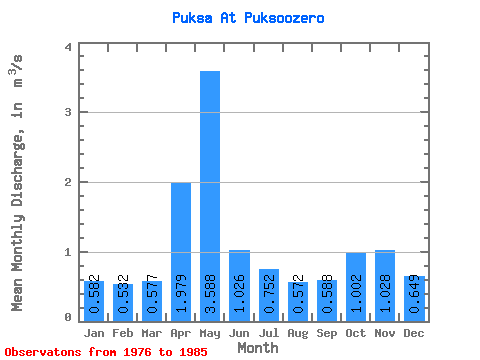
| Statistic | Jan | Feb | Mar | Apr | May | Jun | Jul | Aug | Sep | Oct | Nov | Dec | Annual |
|---|---|---|---|---|---|---|---|---|---|---|---|---|---|
| Mean | 0.58 | 0.53 | 0.58 | 1.98 | 3.59 | 1.03 | 0.75 | 0.57 | 0.59 | 1.00 | 1.03 | 0.65 | 1.08 |
| Standard Deviation | 0.13 | 0.11 | 0.07 | 1.69 | 1.48 | 0.65 | 0.36 | 0.23 | 0.20 | 0.91 | 0.69 | 0.29 | 0.29 |
| Min | 0.46 | 0.39 | 0.45 | 0.52 | 2.12 | 0.44 | 0.45 | 0.38 | 0.43 | 0.39 | 0.35 | 0.34 | 0.69 |
| Max | 0.84 | 0.68 | 0.65 | 6.06 | 6.64 | 2.09 | 1.47 | 1.14 | 1.05 | 3.39 | 2.37 | 1.31 | 1.54 |
| Coefficient of Variation | 0.22 | 0.21 | 0.12 | 0.85 | 0.41 | 0.63 | 0.48 | 0.39 | 0.35 | 0.91 | 0.67 | 0.45 | 0.27 |
 Return to R-Arctic Net Home Page