|
|
|||||||||||||||||
| Point ID: 8898 | Downloads | Plots | Site Data | Code: 70556 |
|
|
|||||||||||||||||
| Download | |
|---|---|
| Site Descriptor Information | Site Time Series Data |
| Link to all available data | |
| View: | Time Series | All |
| Units: | m3/s |
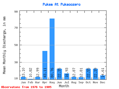
| Statistic | Jan | Feb | Mar | Apr | May | Jun | Jul | Aug | Sep | Oct | Nov | Dec | Annual |
|---|---|---|---|---|---|---|---|---|---|---|---|---|---|
| Mean | 13.10 | 10.91 | 12.98 | 43.10 | 80.74 | 22.34 | 16.93 | 12.88 | 12.80 | 22.55 | 22.39 | 14.61 | 286.70 |
| Standard Deviation | 2.89 | 2.31 | 1.53 | 36.85 | 33.31 | 14.11 | 8.22 | 5.07 | 4.45 | 20.54 | 15.02 | 6.55 | 78.21 |
| Min | 10.35 | 8.00 | 10.13 | 11.33 | 47.71 | 9.58 | 10.13 | 8.55 | 9.37 | 8.78 | 7.62 | 7.65 | 182.55 |
| Max | 18.90 | 13.94 | 14.63 | 132.00 | 149.43 | 45.52 | 33.08 | 25.66 | 22.87 | 76.29 | 51.62 | 29.48 | 407.76 |
| Coefficient of Variation | 0.22 | 0.21 | 0.12 | 0.85 | 0.41 | 0.63 | 0.48 | 0.39 | 0.35 | 0.91 | 0.67 | 0.45 | 0.27 |
 Return to R-Arctic Net Home Page