|
|
|||||||||||||||||
| Point ID: 8867 | Downloads | Plots | Site Data | Code: 70412 |
|
|
|||||||||||||||||
| Download | |
|---|---|
| Site Descriptor Information | Site Time Series Data |
| Link to all available data | |
| View: | Time Series | All |
| Units: | mm |
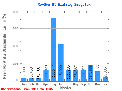
| Statistic | Jan | Feb | Mar | Apr | May | Jun | Jul | Aug | Sep | Oct | Nov | Dec | Annual |
|---|---|---|---|---|---|---|---|---|---|---|---|---|---|
| Mean | 36.00 | 35.46 | 35.19 | 128.33 | 719.65 | 419.00 | 131.24 | 126.37 | 129.91 | 187.84 | 114.17 | 52.34 | 176.14 |
| Standard Deviation | 4.42 | 4.01 | 3.98 | 125.59 | 161.35 | 218.71 | 54.14 | 62.14 | 58.84 | 60.51 | 44.45 | 10.61 | 25.28 |
| Min | 27.00 | 27.00 | 27.00 | 37.10 | 397.00 | 190.00 | 62.00 | 57.00 | 39.80 | 94.00 | 48.40 | 37.20 | 140.68 |
| Max | 42.50 | 42.50 | 42.50 | 475.00 | 1010.00 | 1020.00 | 211.00 | 281.00 | 248.00 | 277.00 | 198.00 | 75.00 | 226.60 |
| Coefficient of Variation | 0.12 | 0.11 | 0.11 | 0.98 | 0.22 | 0.52 | 0.41 | 0.49 | 0.45 | 0.32 | 0.39 | 0.20 | 0.14 |
 Return to R-Arctic Net Home Page