|
|
|||||||||||||||||
| Point ID: 8867 | Downloads | Plots | Site Data | Code: 70412 |
|
|
|||||||||||||||||
| Download | |
|---|---|
| Site Descriptor Information | Site Time Series Data |
| Link to all available data | |
| View: | Time Series | All |
| Units: | m3/s |
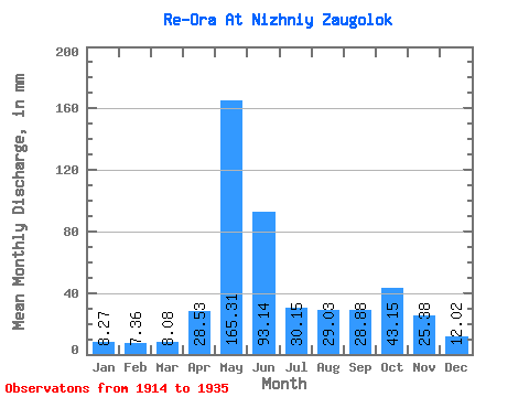
| Statistic | Jan | Feb | Mar | Apr | May | Jun | Jul | Aug | Sep | Oct | Nov | Dec | Annual |
|---|---|---|---|---|---|---|---|---|---|---|---|---|---|
| Mean | 8.27 | 7.42 | 8.08 | 28.53 | 165.28 | 93.14 | 30.14 | 29.02 | 28.88 | 43.14 | 25.38 | 12.02 | 476.75 |
| Standard Deviation | 1.02 | 0.84 | 0.91 | 27.92 | 37.06 | 48.62 | 12.44 | 14.27 | 13.08 | 13.90 | 9.88 | 2.44 | 68.42 |
| Min | 6.20 | 5.65 | 6.20 | 8.25 | 91.18 | 42.24 | 14.24 | 13.09 | 8.85 | 21.59 | 10.76 | 8.54 | 380.76 |
| Max | 9.76 | 8.89 | 9.76 | 105.59 | 231.97 | 226.74 | 48.46 | 64.54 | 55.13 | 63.62 | 44.02 | 17.23 | 613.34 |
| Coefficient of Variation | 0.12 | 0.11 | 0.11 | 0.98 | 0.22 | 0.52 | 0.41 | 0.49 | 0.45 | 0.32 | 0.39 | 0.20 | 0.14 |
 Return to R-Arctic Net Home Page