|
|
|||||||||||||||||
| Point ID: 8866 | Downloads | Plots | Site Data | Code: 70407 |
|
|
|||||||||||||||||
| Download | |
|---|---|
| Site Descriptor Information | Site Time Series Data |
| Link to all available data | |
| View: | Time Series | All |
| Units: | mm |
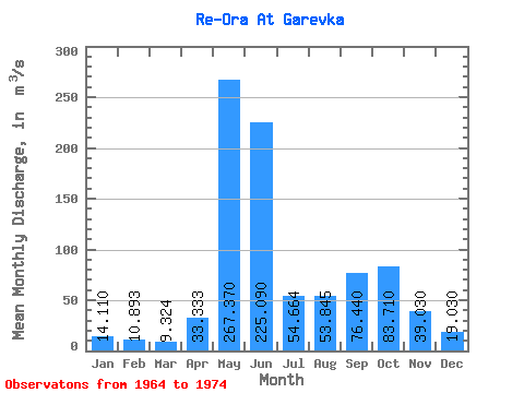
| Statistic | Jan | Feb | Mar | Apr | May | Jun | Jul | Aug | Sep | Oct | Nov | Dec | Annual |
|---|---|---|---|---|---|---|---|---|---|---|---|---|---|
| Mean | 14.11 | 10.89 | 9.32 | 33.33 | 267.37 | 225.09 | 54.66 | 53.84 | 76.44 | 83.71 | 39.03 | 19.03 | 72.94 |
| Standard Deviation | 2.58 | 2.23 | 3.16 | 33.31 | 99.26 | 122.01 | 22.64 | 33.75 | 34.81 | 42.99 | 21.64 | 3.72 | 9.31 |
| Min | 10.90 | 6.57 | 4.17 | 6.83 | 94.70 | 77.40 | 30.10 | 29.00 | 21.70 | 33.30 | 20.70 | 15.60 | 61.32 |
| Max | 18.50 | 14.10 | 13.60 | 99.80 | 379.00 | 367.00 | 109.00 | 137.00 | 131.00 | 191.00 | 95.70 | 27.80 | 94.17 |
| Coefficient of Variation | 0.18 | 0.20 | 0.34 | 1.00 | 0.37 | 0.54 | 0.41 | 0.63 | 0.46 | 0.51 | 0.55 | 0.20 | 0.13 |
 Return to R-Arctic Net Home Page