|
|
|||||||||||||||||
| Point ID: 8866 | Downloads | Plots | Site Data | Code: 70407 |
|
|
|||||||||||||||||
| Download | |
|---|---|
| Site Descriptor Information | Site Time Series Data |
| Link to all available data | |
| View: | Time Series | All |
| Units: | m3/s |
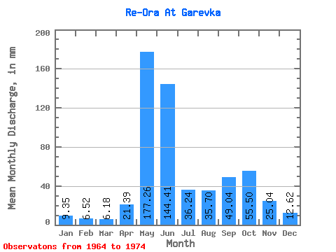
| Statistic | Jan | Feb | Mar | Apr | May | Jun | Jul | Aug | Sep | Oct | Nov | Dec | Annual |
|---|---|---|---|---|---|---|---|---|---|---|---|---|---|
| Mean | 9.35 | 6.58 | 6.18 | 21.39 | 177.23 | 144.41 | 36.23 | 35.69 | 49.04 | 55.49 | 25.04 | 12.61 | 569.83 |
| Standard Deviation | 1.71 | 1.34 | 2.09 | 21.37 | 65.79 | 78.28 | 15.01 | 22.37 | 22.33 | 28.50 | 13.88 | 2.46 | 72.74 |
| Min | 7.22 | 3.97 | 2.76 | 4.38 | 62.77 | 49.66 | 19.95 | 19.22 | 13.92 | 22.07 | 13.28 | 10.34 | 479.00 |
| Max | 12.26 | 8.52 | 9.02 | 64.03 | 251.23 | 235.46 | 72.25 | 90.81 | 84.05 | 126.61 | 61.40 | 18.43 | 735.68 |
| Coefficient of Variation | 0.18 | 0.20 | 0.34 | 1.00 | 0.37 | 0.54 | 0.41 | 0.63 | 0.46 | 0.51 | 0.55 | 0.20 | 0.13 |
 Return to R-Arctic Net Home Page