|
|
|||||||||||||||||
| Point ID: 8862 | Downloads | Plots | Site Data | Code: 70353 |
|
|
|||||||||||||||||
| Download | |
|---|---|
| Site Descriptor Information | Site Time Series Data |
| Link to all available data | |
| View: | Time Series | All |
| Units: | mm |
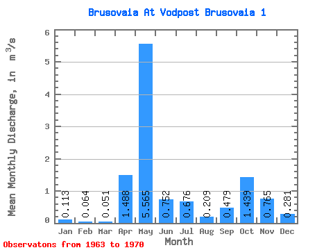
| Statistic | Jan | Feb | Mar | Apr | May | Jun | Jul | Aug | Sep | Oct | Nov | Dec | Annual |
|---|---|---|---|---|---|---|---|---|---|---|---|---|---|
| Mean | 0.11 | 0.06 | 0.05 | 1.49 | 5.56 | 0.75 | 0.68 | 0.21 | 0.48 | 1.44 | 0.77 | 0.28 | 0.98 |
| Standard Deviation | 0.05 | 0.03 | 0.02 | 1.36 | 2.67 | 0.31 | 0.72 | 0.14 | 0.52 | 1.20 | 0.32 | 0.26 | 0.27 |
| Min | 0.06 | 0.03 | 0.03 | 0.08 | 1.60 | 0.44 | 0.12 | 0.05 | 0.12 | 0.21 | 0.19 | 0.11 | 0.59 |
| Max | 0.19 | 0.12 | 0.09 | 3.88 | 8.92 | 1.26 | 2.11 | 0.46 | 1.55 | 3.69 | 1.11 | 0.86 | 1.35 |
| Coefficient of Variation | 0.44 | 0.50 | 0.40 | 0.91 | 0.48 | 0.42 | 1.06 | 0.69 | 1.09 | 0.84 | 0.41 | 0.92 | 0.28 |
 Return to R-Arctic Net Home Page