|
|
|||||||||||||||||
| Point ID: 8862 | Downloads | Plots | Site Data | Code: 70353 |
|
|
|||||||||||||||||
| Download | |
|---|---|
| Site Descriptor Information | Site Time Series Data |
| Link to all available data | |
| View: | Time Series | All |
| Units: | m3/s |
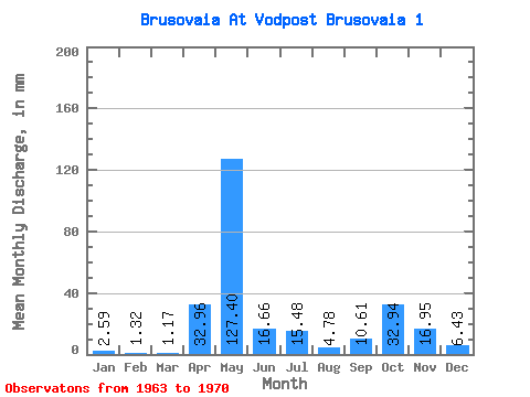
| Statistic | Jan | Feb | Mar | Apr | May | Jun | Jul | Aug | Sep | Oct | Nov | Dec | Annual |
|---|---|---|---|---|---|---|---|---|---|---|---|---|---|
| Mean | 2.60 | 1.34 | 1.17 | 32.96 | 127.37 | 16.67 | 15.48 | 4.79 | 10.61 | 32.93 | 16.95 | 6.44 | 265.78 |
| Standard Deviation | 1.14 | 0.66 | 0.47 | 30.12 | 61.00 | 6.94 | 16.39 | 3.31 | 11.58 | 27.53 | 7.00 | 5.91 | 73.91 |
| Min | 1.33 | 0.69 | 0.71 | 1.75 | 36.62 | 9.75 | 2.75 | 1.19 | 2.66 | 4.81 | 4.21 | 2.45 | 160.27 |
| Max | 4.35 | 2.46 | 2.11 | 85.96 | 204.15 | 27.91 | 48.30 | 10.53 | 34.34 | 84.46 | 24.59 | 19.68 | 365.44 |
| Coefficient of Variation | 0.44 | 0.50 | 0.40 | 0.91 | 0.48 | 0.42 | 1.06 | 0.69 | 1.09 | 0.84 | 0.41 | 0.92 | 0.28 |
 Return to R-Arctic Net Home Page