|
|
|||||||||||||||||
| Point ID: 8855 | Downloads | Plots | Site Data | Code: 70303 |
|
|
|||||||||||||||||
| Download | |
|---|---|
| Site Descriptor Information | Site Time Series Data |
| Link to all available data | |
| View: | Time Series | All |
| Units: | mm |
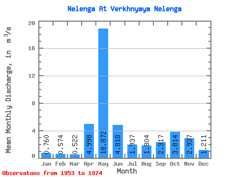
| Statistic | Jan | Feb | Mar | Apr | May | Jun | Jul | Aug | Sep | Oct | Nov | Dec | Annual |
|---|---|---|---|---|---|---|---|---|---|---|---|---|---|
| Mean | 0.76 | 0.57 | 0.52 | 5.00 | 18.87 | 4.82 | 1.94 | 1.80 | 2.32 | 3.81 | 2.94 | 1.21 | 3.71 |
| Standard Deviation | 0.27 | 0.29 | 0.23 | 6.02 | 7.90 | 2.11 | 1.08 | 2.87 | 1.84 | 2.13 | 1.48 | 0.63 | 1.00 |
| Min | 0.39 | 0.27 | 0.11 | 0.42 | 6.36 | 1.18 | 0.27 | 0.19 | 0.23 | 0.60 | 0.81 | 0.43 | 2.17 |
| Max | 1.44 | 1.55 | 1.20 | 23.60 | 35.30 | 10.40 | 4.81 | 13.40 | 7.72 | 9.22 | 5.91 | 3.46 | 5.66 |
| Coefficient of Variation | 0.36 | 0.50 | 0.44 | 1.20 | 0.42 | 0.44 | 0.56 | 1.59 | 0.80 | 0.56 | 0.51 | 0.52 | 0.27 |
 Return to R-Arctic Net Home Page