|
|
|||||||||||||||||
| Point ID: 8855 | Downloads | Plots | Site Data | Code: 70303 |
|
|
|||||||||||||||||
| Download | |
|---|---|
| Site Descriptor Information | Site Time Series Data |
| Link to all available data | |
| View: | Time Series | All |
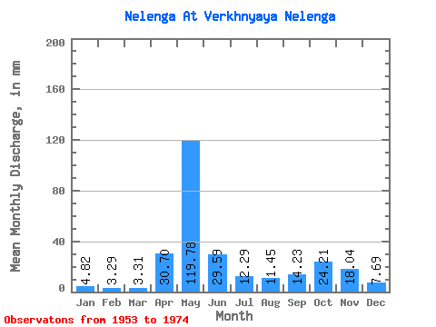
| Units: | m3/s |
| Statistic | Jan | Feb | Mar | Apr | May | Jun | Jul | Aug | Sep | Oct | Nov | Dec | Annual |
|---|---|---|---|---|---|---|---|---|---|---|---|---|---|
| Mean | 4.82 | 3.32 | 3.31 | 30.70 | 119.76 | 29.59 | 12.29 | 11.45 | 14.23 | 24.20 | 18.04 | 7.69 | 277.73 |
| Standard Deviation | 1.72 | 1.67 | 1.45 | 36.97 | 50.14 | 12.97 | 6.87 | 18.19 | 11.32 | 13.54 | 9.12 | 4.02 | 75.01 |
| Min | 2.48 | 1.56 | 0.70 | 2.58 | 40.36 | 7.25 | 1.72 | 1.21 | 1.41 | 3.81 | 4.97 | 2.73 | 162.04 |
| Max | 9.14 | 8.96 | 7.62 | 144.96 | 224.01 | 63.88 | 30.52 | 85.04 | 47.42 | 58.51 | 36.30 | 21.96 | 423.23 |
| Coefficient of Variation | 0.36 | 0.50 | 0.44 | 1.20 | 0.42 | 0.44 | 0.56 | 1.59 | 0.80 | 0.56 | 0.51 | 0.52 | 0.27 |
 Return to R-Arctic Net Home Page