|
|
|||||||||||||||||
| Point ID: 8850 | Downloads | Plots | Site Data | Code: 70236 |
|
|
|||||||||||||||||
| Download | |
|---|---|
| Site Descriptor Information | Site Time Series Data |
| Link to all available data | |
| View: | Time Series | All |
| Units: | mm |
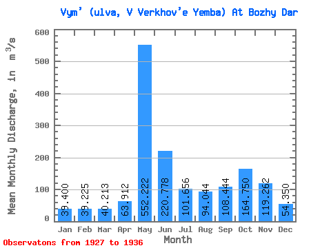
| Statistic | Jan | Feb | Mar | Apr | May | Jun | Jul | Aug | Sep | Oct | Nov | Dec | Annual |
|---|---|---|---|---|---|---|---|---|---|---|---|---|---|
| Mean | 39.40 | 39.23 | 40.21 | 63.91 | 552.22 | 220.78 | 101.66 | 94.04 | 108.44 | 164.75 | 119.26 | 54.35 | 137.59 |
| Standard Deviation | 6.05 | 5.52 | 5.53 | 26.32 | 137.44 | 56.49 | 31.98 | 53.18 | 56.42 | 59.93 | 32.48 | 10.96 | 19.38 |
| Min | 26.80 | 28.70 | 29.40 | 36.50 | 364.00 | 133.00 | 60.30 | 43.70 | 44.10 | 106.00 | 66.00 | 38.90 | 115.58 |
| Max | 46.00 | 46.80 | 47.40 | 104.00 | 724.00 | 342.00 | 160.00 | 203.00 | 217.00 | 297.00 | 156.00 | 70.20 | 162.29 |
| Coefficient of Variation | 0.15 | 0.14 | 0.14 | 0.41 | 0.25 | 0.26 | 0.32 | 0.56 | 0.52 | 0.36 | 0.27 | 0.20 | 0.14 |
 Return to R-Arctic Net Home Page