|
|
|||||||||||||||||
| Point ID: 8850 | Downloads | Plots | Site Data | Code: 70236 |
|
|
|||||||||||||||||
| Download | |
|---|---|
| Site Descriptor Information | Site Time Series Data |
| Link to all available data | |
| View: | Time Series | All |
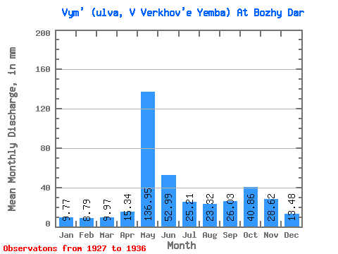
| Units: | m3/s |
| Statistic | Jan | Feb | Mar | Apr | May | Jun | Jul | Aug | Sep | Oct | Nov | Dec | Annual |
|---|---|---|---|---|---|---|---|---|---|---|---|---|---|
| Mean | 9.77 | 8.86 | 9.97 | 15.34 | 136.93 | 52.99 | 25.21 | 23.32 | 26.03 | 40.85 | 28.62 | 13.48 | 402.07 |
| Standard Deviation | 1.50 | 1.25 | 1.37 | 6.32 | 34.08 | 13.56 | 7.93 | 13.19 | 13.54 | 14.86 | 7.79 | 2.72 | 56.64 |
| Min | 6.64 | 6.48 | 7.29 | 8.76 | 90.26 | 31.92 | 14.95 | 10.84 | 10.58 | 26.28 | 15.84 | 9.65 | 337.74 |
| Max | 11.41 | 10.57 | 11.75 | 24.96 | 179.53 | 82.08 | 39.67 | 50.34 | 52.08 | 73.64 | 37.44 | 17.41 | 474.25 |
| Coefficient of Variation | 0.15 | 0.14 | 0.14 | 0.41 | 0.25 | 0.26 | 0.32 | 0.56 | 0.52 | 0.36 | 0.27 | 0.20 | 0.14 |
 Return to R-Arctic Net Home Page