|
|
|||||||||||||||||
| Point ID: 8839 | Downloads | Plots | Site Data | Code: 70107 |
|
|
|||||||||||||||||
| Download | |
|---|---|
| Site Descriptor Information | Site Time Series Data |
| Link to all available data | |
| View: | Time Series | All |
| Units: | mm |
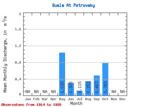
| Statistic | Jan | Feb | Mar | Apr | May | Jun | Jul | Aug | Sep | Oct | Nov | Dec | Annual |
|---|---|---|---|---|---|---|---|---|---|---|---|---|---|
| Mean | 1.03 | 0.30 | 0.12 | 0.35 | 0.49 | 0.78 | |||||||
| Standard Deviation | 0.69 | 0.22 | 0.10 | 0.35 | 0.41 | 0.62 | |||||||
| Min | 0.19 | 0.05 | 0.02 | 0.01 | 0.05 | 0.42 | |||||||
| Max | 2.13 | 0.64 | 0.41 | 1.01 | 1.33 | 1.50 | |||||||
| Coefficient of Variation | 0.67 | 0.73 | 0.91 | 1.01 | 0.84 | 0.79 |
 Return to R-Arctic Net Home Page