|
|
|||||||||||||||||
| Point ID: 8839 | Downloads | Plots | Site Data | Code: 70107 |
|
|
|||||||||||||||||
| Download | |
|---|---|
| Site Descriptor Information | Site Time Series Data |
| Link to all available data | |
| View: | Time Series | All |
| Units: | m3/s |
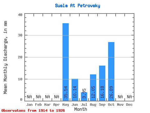
| Statistic | Jan | Feb | Mar | Apr | May | Jun | Jul | Aug | Sep | Oct | Nov | Dec | Annual |
|---|---|---|---|---|---|---|---|---|---|---|---|---|---|
| Mean | 35.54 | 10.13 | 3.96 | 12.05 | 16.17 | 26.89 | |||||||
| Standard Deviation | 23.72 | 7.36 | 3.62 | 12.15 | 13.62 | 21.31 | |||||||
| Min | 6.52 | 1.66 | 0.69 | 0.34 | 1.66 | 14.42 | |||||||
| Max | 73.15 | 21.27 | 14.08 | 34.68 | 44.20 | 51.50 | |||||||
| Coefficient of Variation | 0.67 | 0.73 | 0.91 | 1.01 | 0.84 | 0.79 |
 Return to R-Arctic Net Home Page