|
|
|||||||||||||||||
| Point ID: 883 | Downloads | Plots | Site Data | Code: 07FB004 |
|
|
|||||||||||||||||
| Download | |
|---|---|
| Site Descriptor Information | Site Time Series Data |
| Link to all available data | |
| View: | Time Series | All |
| Units: | mm |
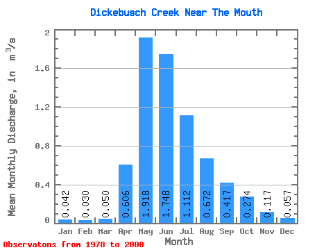
| Statistic | Jan | Feb | Mar | Apr | May | Jun | Jul | Aug | Sep | Oct | Nov | Dec | Annual |
|---|---|---|---|---|---|---|---|---|---|---|---|---|---|
| Mean | 0.04 | 0.03 | 0.05 | 0.61 | 1.92 | 1.75 | 1.11 | 0.67 | 0.42 | 0.27 | 0.12 | 0.06 | 0.59 |
| Standard Deviation | 0.05 | 0.03 | 0.05 | 0.35 | 1.42 | 1.52 | 1.13 | 1.34 | 0.60 | 0.28 | 0.12 | 0.05 | 0.25 |
| Min | 0.00 | 0.00 | 0.00 | 0.02 | 0.29 | 0.22 | 0.05 | 0.03 | 0.04 | 0.05 | 0.01 | 0.01 | 0.17 |
| Max | 0.18 | 0.12 | 0.22 | 1.14 | 6.74 | 7.40 | 4.17 | 6.54 | 2.76 | 1.20 | 0.48 | 0.16 | 0.99 |
| Coefficient of Variation | 1.15 | 1.02 | 0.96 | 0.58 | 0.74 | 0.87 | 1.01 | 2.00 | 1.45 | 1.02 | 0.99 | 0.90 | 0.42 |
 Return to R-Arctic Net Home Page