|
|
|||||||||||||||||
| Point ID: 883 | Downloads | Plots | Site Data | Code: 07FB004 |
|
|
|||||||||||||||||
| Download | |
|---|---|
| Site Descriptor Information | Site Time Series Data |
| Link to all available data | |
| View: | Time Series | All |
| Units: | m3/s |
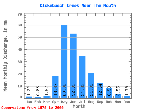
| Statistic | Jan | Feb | Mar | Apr | May | Jun | Jul | Aug | Sep | Oct | Nov | Dec | Annual |
|---|---|---|---|---|---|---|---|---|---|---|---|---|---|
| Mean | 1.31 | 0.85 | 1.56 | 18.36 | 60.09 | 53.00 | 34.82 | 21.05 | 12.63 | 8.57 | 3.55 | 1.78 | 216.60 |
| Standard Deviation | 1.51 | 0.87 | 1.51 | 10.65 | 44.39 | 46.21 | 35.36 | 42.06 | 18.35 | 8.71 | 3.53 | 1.60 | 92.10 |
| Min | 0.00 | 0.00 | 0.12 | 0.64 | 9.12 | 6.76 | 1.63 | 0.88 | 1.36 | 1.44 | 0.21 | 0.16 | 64.63 |
| Max | 5.54 | 3.34 | 6.92 | 34.56 | 211.11 | 224.34 | 130.61 | 204.84 | 83.67 | 37.59 | 14.55 | 4.92 | 366.45 |
| Coefficient of Variation | 1.15 | 1.02 | 0.96 | 0.58 | 0.74 | 0.87 | 1.01 | 2.00 | 1.45 | 1.02 | 0.99 | 0.90 | 0.42 |
 Return to R-Arctic Net Home Page