|
|
|||||||||||||||||
| Point ID: 8828 | Downloads | Plots | Site Data | Code: 70033 |
|
|
|||||||||||||||||
| Download | |
|---|---|
| Site Descriptor Information | Site Time Series Data |
| Link to all available data | |
| View: | Time Series | All |
| Units: | mm |
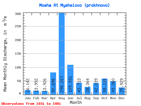
| Statistic | Jan | Feb | Mar | Apr | May | Jun | Jul | Aug | Sep | Oct | Nov | Dec | Annual |
|---|---|---|---|---|---|---|---|---|---|---|---|---|---|
| Mean | 16.14 | 13.99 | 13.93 | 80.70 | 298.27 | 109.33 | 43.71 | 28.36 | 42.04 | 58.12 | 49.06 | 25.93 | 64.73 |
| Standard Deviation | 5.37 | 3.44 | 2.84 | 61.42 | 100.41 | 56.23 | 21.16 | 19.93 | 45.55 | 38.14 | 28.18 | 14.28 | 15.43 |
| Min | 7.13 | 8.15 | 7.13 | 10.90 | 123.00 | 25.00 | 13.70 | 8.19 | 13.10 | 12.90 | 11.30 | 6.60 | 40.58 |
| Max | 31.90 | 23.20 | 21.30 | 232.00 | 528.00 | 339.00 | 110.00 | 106.00 | 273.00 | 197.00 | 123.00 | 86.10 | 103.01 |
| Coefficient of Variation | 0.33 | 0.25 | 0.20 | 0.76 | 0.34 | 0.51 | 0.48 | 0.70 | 1.08 | 0.66 | 0.57 | 0.55 | 0.24 |
 Return to R-Arctic Net Home Page