|
|
|||||||||||||||||
| Point ID: 8828 | Downloads | Plots | Site Data | Code: 70033 |
|
|
|||||||||||||||||
| Download | |
|---|---|
| Site Descriptor Information | Site Time Series Data |
| Link to all available data | |
| View: | Time Series | All |
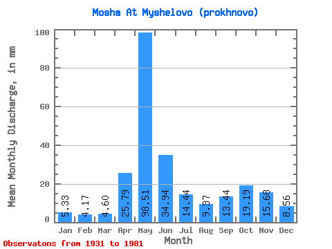
| Units: | m3/s |
| Statistic | Jan | Feb | Mar | Apr | May | Jun | Jul | Aug | Sep | Oct | Nov | Dec | Annual |
|---|---|---|---|---|---|---|---|---|---|---|---|---|---|
| Mean | 5.33 | 4.21 | 4.60 | 25.79 | 98.49 | 34.94 | 14.44 | 9.37 | 13.44 | 19.19 | 15.68 | 8.56 | 251.91 |
| Standard Deviation | 1.77 | 1.04 | 0.94 | 19.63 | 33.16 | 17.97 | 6.99 | 6.58 | 14.56 | 12.59 | 9.01 | 4.71 | 60.04 |
| Min | 2.35 | 2.45 | 2.35 | 3.48 | 40.62 | 7.99 | 4.52 | 2.70 | 4.19 | 4.26 | 3.61 | 2.18 | 157.93 |
| Max | 10.53 | 6.98 | 7.03 | 74.15 | 174.35 | 108.35 | 36.32 | 35.00 | 87.25 | 65.05 | 39.31 | 28.43 | 400.86 |
| Coefficient of Variation | 0.33 | 0.25 | 0.20 | 0.76 | 0.34 | 0.51 | 0.48 | 0.70 | 1.08 | 0.66 | 0.57 | 0.55 | 0.24 |
 Return to R-Arctic Net Home Page