|
|
|||||||||||||||||
| Point ID: 8820 | Downloads | Plots | Site Data | Code: 12392 |
|
|
|||||||||||||||||
| Download | |
|---|---|
| Site Descriptor Information | Site Time Series Data |
| Link to all available data | |
| View: | Time Series | All |
| Units: | mm |
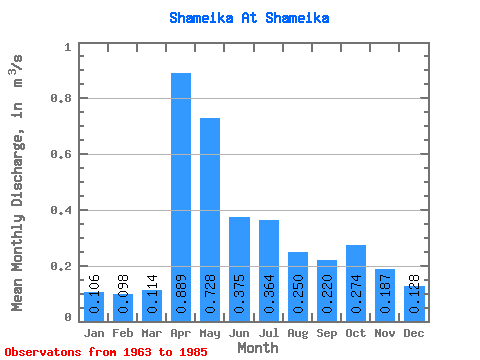
| Statistic | Jan | Feb | Mar | Apr | May | Jun | Jul | Aug | Sep | Oct | Nov | Dec | Annual |
|---|---|---|---|---|---|---|---|---|---|---|---|---|---|
| Mean | 0.11 | 0.10 | 0.11 | 0.89 | 0.73 | 0.38 | 0.36 | 0.25 | 0.22 | 0.27 | 0.19 | 0.13 | 0.31 |
| Standard Deviation | 0.05 | 0.04 | 0.04 | 0.55 | 0.48 | 0.21 | 0.51 | 0.30 | 0.24 | 0.25 | 0.12 | 0.07 | 0.14 |
| Min | 0.01 | 0.02 | 0.06 | 0.21 | 0.10 | 0.09 | 0.05 | 0.04 | 0.05 | 0.06 | 0.04 | 0.04 | 0.08 |
| Max | 0.22 | 0.18 | 0.23 | 2.02 | 2.07 | 0.85 | 2.41 | 1.39 | 1.12 | 0.99 | 0.58 | 0.26 | 0.55 |
| Coefficient of Variation | 0.51 | 0.41 | 0.39 | 0.62 | 0.67 | 0.56 | 1.39 | 1.19 | 1.11 | 0.91 | 0.66 | 0.51 | 0.44 |
 Return to R-Arctic Net Home Page