|
|
|||||||||||||||||
| Point ID: 8820 | Downloads | Plots | Site Data | Code: 12392 |
|
|
|||||||||||||||||
| Download | |
|---|---|
| Site Descriptor Information | Site Time Series Data |
| Link to all available data | |
| View: | Time Series | All |
| Units: | m3/s |
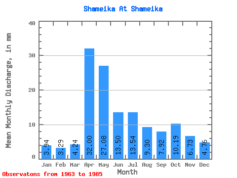
| Statistic | Jan | Feb | Mar | Apr | May | Jun | Jul | Aug | Sep | Oct | Nov | Dec | Annual |
|---|---|---|---|---|---|---|---|---|---|---|---|---|---|
| Mean | 3.95 | 3.31 | 4.25 | 31.99 | 27.07 | 13.49 | 13.55 | 9.31 | 7.91 | 10.18 | 6.73 | 4.77 | 137.39 |
| Standard Deviation | 2.00 | 1.36 | 1.67 | 19.89 | 18.00 | 7.53 | 18.83 | 11.06 | 8.77 | 9.27 | 4.42 | 2.44 | 59.89 |
| Min | 0.56 | 0.61 | 2.08 | 7.56 | 3.65 | 3.10 | 1.82 | 1.52 | 1.80 | 2.08 | 1.26 | 1.41 | 36.20 |
| Max | 8.18 | 6.10 | 8.55 | 72.72 | 77.02 | 30.60 | 89.68 | 51.72 | 40.32 | 36.82 | 20.88 | 9.67 | 240.72 |
| Coefficient of Variation | 0.51 | 0.41 | 0.39 | 0.62 | 0.67 | 0.56 | 1.39 | 1.19 | 1.11 | 0.91 | 0.66 | 0.51 | 0.44 |
 Return to R-Arctic Net Home Page