|
|
|||||||||||||||||
| Point ID: 8819 | Downloads | Plots | Site Data | Code: 12389 |
|
|
|||||||||||||||||
| Download | |
|---|---|
| Site Descriptor Information | Site Time Series Data |
| Link to all available data | |
| View: | Time Series | All |
| Units: | mm |
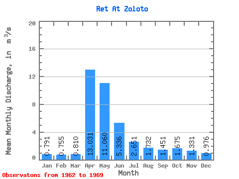
| Statistic | Jan | Feb | Mar | Apr | May | Jun | Jul | Aug | Sep | Oct | Nov | Dec | Annual |
|---|---|---|---|---|---|---|---|---|---|---|---|---|---|
| Mean | 0.79 | 0.76 | 0.81 | 13.03 | 11.06 | 5.34 | 2.65 | 1.73 | 1.45 | 1.68 | 1.33 | 0.98 | 3.47 |
| Standard Deviation | 0.39 | 0.35 | 0.36 | 9.90 | 7.20 | 3.37 | 1.61 | 1.16 | 0.98 | 1.25 | 0.66 | 0.55 | 1.61 |
| Min | 0.28 | 0.25 | 0.27 | 1.98 | 0.84 | 1.04 | 0.82 | 0.77 | 0.55 | 0.58 | 0.65 | 0.48 | 1.07 |
| Max | 1.30 | 1.16 | 1.37 | 32.40 | 19.50 | 9.21 | 5.72 | 3.81 | 3.57 | 4.45 | 2.79 | 2.01 | 5.94 |
| Coefficient of Variation | 0.49 | 0.46 | 0.44 | 0.76 | 0.65 | 0.63 | 0.61 | 0.67 | 0.68 | 0.74 | 0.49 | 0.56 | 0.46 |
 Return to R-Arctic Net Home Page