|
|
|||||||||||||||||
| Point ID: 8819 | Downloads | Plots | Site Data | Code: 12389 |
|
|
|||||||||||||||||
| Download | |
|---|---|
| Site Descriptor Information | Site Time Series Data |
| Link to all available data | |
| View: | Time Series | All |
| Units: | m3/s |
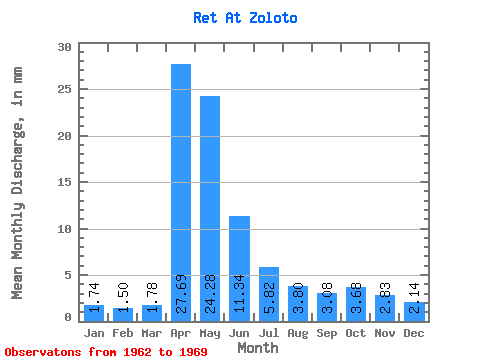
| Statistic | Jan | Feb | Mar | Apr | May | Jun | Jul | Aug | Sep | Oct | Nov | Dec | Annual |
|---|---|---|---|---|---|---|---|---|---|---|---|---|---|
| Mean | 1.74 | 1.51 | 1.78 | 27.69 | 24.28 | 11.34 | 5.82 | 3.80 | 3.08 | 3.68 | 2.83 | 2.14 | 89.68 |
| Standard Deviation | 0.86 | 0.69 | 0.78 | 21.03 | 15.81 | 7.16 | 3.53 | 2.54 | 2.09 | 2.74 | 1.39 | 1.21 | 41.62 |
| Min | 0.61 | 0.50 | 0.59 | 4.21 | 1.84 | 2.21 | 1.80 | 1.69 | 1.17 | 1.27 | 1.38 | 1.05 | 27.68 |
| Max | 2.85 | 2.32 | 3.01 | 68.84 | 42.80 | 19.57 | 12.56 | 8.36 | 7.58 | 9.77 | 5.93 | 4.41 | 153.60 |
| Coefficient of Variation | 0.49 | 0.46 | 0.44 | 0.76 | 0.65 | 0.63 | 0.61 | 0.67 | 0.68 | 0.74 | 0.49 | 0.56 | 0.46 |
 Return to R-Arctic Net Home Page