|
|
|||||||||||||||||
| Point ID: 8811 | Downloads | Plots | Site Data | Code: 12340 |
|
|
|||||||||||||||||
| Download | |
|---|---|
| Site Descriptor Information | Site Time Series Data |
| Link to all available data | |
| View: | Time Series | All |
| Units: | mm |
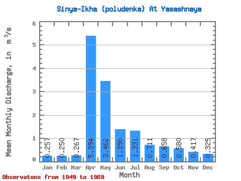
| Statistic | Jan | Feb | Mar | Apr | May | Jun | Jul | Aug | Sep | Oct | Nov | Dec | Annual |
|---|---|---|---|---|---|---|---|---|---|---|---|---|---|
| Mean | 0.26 | 0.25 | 0.27 | 5.39 | 3.46 | 1.39 | 1.33 | 0.71 | 0.66 | 0.58 | 0.42 | 0.33 | 1.25 |
| Standard Deviation | 0.12 | 0.11 | 0.17 | 2.78 | 2.40 | 1.15 | 2.03 | 0.82 | 0.83 | 0.40 | 0.22 | 0.17 | 0.48 |
| Min | 0.12 | 0.10 | 0.08 | 1.77 | 0.75 | 0.44 | 0.25 | 0.18 | 0.24 | 0.23 | 0.17 | 0.12 | 0.52 |
| Max | 0.54 | 0.46 | 0.83 | 11.00 | 8.88 | 4.74 | 7.61 | 3.95 | 4.12 | 1.86 | 0.93 | 0.73 | 2.17 |
| Coefficient of Variation | 0.48 | 0.44 | 0.63 | 0.52 | 0.69 | 0.83 | 1.53 | 1.15 | 1.26 | 0.69 | 0.52 | 0.53 | 0.39 |
 Return to R-Arctic Net Home Page