|
|
|||||||||||||||||
| Point ID: 8811 | Downloads | Plots | Site Data | Code: 12340 |
|
|
|||||||||||||||||
| Download | |
|---|---|
| Site Descriptor Information | Site Time Series Data |
| Link to all available data | |
| View: | Time Series | All |
| Units: | m3/s |
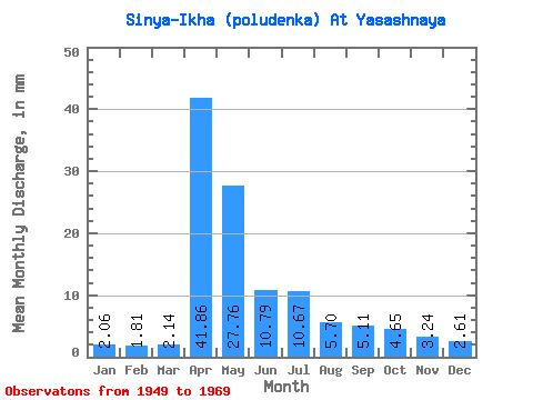
| Statistic | Jan | Feb | Mar | Apr | May | Jun | Jul | Aug | Sep | Oct | Nov | Dec | Annual |
|---|---|---|---|---|---|---|---|---|---|---|---|---|---|
| Mean | 2.06 | 1.83 | 2.14 | 41.86 | 27.76 | 10.79 | 10.67 | 5.70 | 5.10 | 4.65 | 3.23 | 2.61 | 118.44 |
| Standard Deviation | 0.99 | 0.80 | 1.35 | 21.58 | 19.24 | 8.94 | 16.28 | 6.54 | 6.44 | 3.19 | 1.69 | 1.37 | 45.70 |
| Min | 0.96 | 0.73 | 0.67 | 13.74 | 6.01 | 3.42 | 2.00 | 1.44 | 1.86 | 1.84 | 1.32 | 0.96 | 48.90 |
| Max | 4.33 | 3.36 | 6.66 | 85.36 | 71.20 | 36.78 | 61.02 | 31.68 | 31.98 | 14.91 | 7.22 | 5.85 | 204.65 |
| Coefficient of Variation | 0.48 | 0.44 | 0.63 | 0.52 | 0.69 | 0.83 | 1.53 | 1.15 | 1.26 | 0.69 | 0.52 | 0.53 | 0.39 |
 Return to R-Arctic Net Home Page