|
|
|||||||||||||||||
| Point ID: 88 | Downloads | Plots | Site Data | Code: 05AD007 |
|
|
|||||||||||||||||
| Download | |
|---|---|
| Site Descriptor Information | Site Time Series Data |
| Link to all available data | |
| View: | Time Series | All |
| Units: | mm |
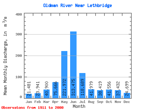
| Statistic | Jan | Feb | Mar | Apr | May | Jun | Jul | Aug | Sep | Oct | Nov | Dec | Annual |
|---|---|---|---|---|---|---|---|---|---|---|---|---|---|
| Mean | 21.48 | 23.94 | 40.90 | 75.67 | 221.97 | 313.48 | 118.69 | 41.98 | 38.42 | 41.56 | 37.43 | 24.70 | 82.42 |
| Standard Deviation | 13.47 | 15.35 | 27.19 | 47.12 | 110.49 | 196.97 | 90.30 | 36.14 | 41.18 | 31.65 | 23.00 | 13.54 | 36.44 |
| Min | 5.52 | 6.53 | 12.40 | 13.80 | 14.30 | 18.00 | 5.05 | 4.78 | 5.91 | 6.34 | 11.80 | 6.08 | 16.71 |
| Max | 94.80 | 87.10 | 144.00 | 222.00 | 553.00 | 941.00 | 401.00 | 182.00 | 249.00 | 162.00 | 105.00 | 78.40 | 194.47 |
| Coefficient of Variation | 0.63 | 0.64 | 0.67 | 0.62 | 0.50 | 0.63 | 0.76 | 0.86 | 1.07 | 0.76 | 0.61 | 0.55 | 0.44 |
 Return to R-Arctic Net Home Page