|
|
|||||||||||||||||
| Point ID: 88 | Downloads | Plots | Site Data | Code: 05AD007 |
|
|
|||||||||||||||||
| Download | |
|---|---|
| Site Descriptor Information | Site Time Series Data |
| Link to all available data | |
| View: | Time Series | All |
| Units: | m3/s |
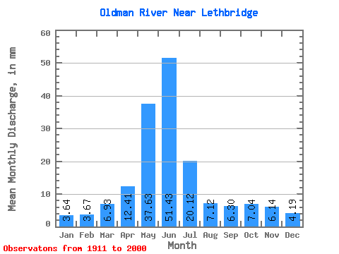
| Statistic | Jan | Feb | Mar | Apr | May | Jun | Jul | Aug | Sep | Oct | Nov | Dec | Annual |
|---|---|---|---|---|---|---|---|---|---|---|---|---|---|
| Mean | 3.38 | 3.44 | 6.44 | 11.54 | 34.97 | 47.80 | 18.70 | 6.61 | 5.86 | 6.55 | 5.71 | 3.89 | 153.00 |
| Standard Deviation | 2.12 | 2.20 | 4.28 | 7.18 | 17.41 | 30.03 | 14.22 | 5.69 | 6.28 | 4.99 | 3.51 | 2.13 | 67.64 |
| Min | 0.87 | 0.94 | 1.95 | 2.10 | 2.25 | 2.74 | 0.80 | 0.75 | 0.90 | 1.00 | 1.80 | 0.96 | 31.02 |
| Max | 14.93 | 12.50 | 22.68 | 33.85 | 87.11 | 143.47 | 63.17 | 28.67 | 37.97 | 25.52 | 16.01 | 12.35 | 361.02 |
| Coefficient of Variation | 0.63 | 0.64 | 0.67 | 0.62 | 0.50 | 0.63 | 0.76 | 0.86 | 1.07 | 0.76 | 0.61 | 0.55 | 0.44 |
 Return to R-Arctic Net Home Page