|
|
|||||||||||||||||
| Point ID: 8788 | Downloads | Plots | Site Data | Code: 12207 |
|
|
|||||||||||||||||
| Download | |
|---|---|
| Site Descriptor Information | Site Time Series Data |
| Link to all available data | |
| View: | Time Series | All |
| Units: | mm |
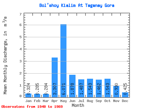
| Statistic | Jan | Feb | Mar | Apr | May | Jun | Jul | Aug | Sep | Oct | Nov | Dec | Annual |
|---|---|---|---|---|---|---|---|---|---|---|---|---|---|
| Mean | 0.32 | 0.28 | 0.28 | 3.31 | 6.07 | 1.88 | 1.49 | 1.54 | 1.46 | 1.54 | 0.93 | 0.42 | 1.61 |
| Standard Deviation | 0.11 | 0.09 | 0.08 | 1.71 | 2.64 | 1.38 | 1.05 | 1.39 | 1.06 | 0.82 | 0.56 | 0.18 | 0.37 |
| Min | 0.16 | 0.12 | 0.12 | 0.73 | 1.73 | 0.26 | 0.22 | 0.19 | 0.23 | 0.30 | 0.21 | 0.23 | 0.70 |
| Max | 0.64 | 0.47 | 0.46 | 6.13 | 12.50 | 6.38 | 4.16 | 5.39 | 4.06 | 4.06 | 2.91 | 0.86 | 2.37 |
| Coefficient of Variation | 0.34 | 0.33 | 0.27 | 0.52 | 0.43 | 0.74 | 0.70 | 0.90 | 0.73 | 0.53 | 0.60 | 0.42 | 0.23 |
 Return to R-Arctic Net Home Page