|
|
|||||||||||||||||
| Point ID: 8788 | Downloads | Plots | Site Data | Code: 12207 |
|
|
|||||||||||||||||
| Download | |
|---|---|
| Site Descriptor Information | Site Time Series Data |
| Link to all available data | |
| View: | Time Series | All |
| Units: | m3/s |
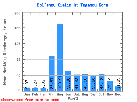
| Statistic | Jan | Feb | Mar | Apr | May | Jun | Jul | Aug | Sep | Oct | Nov | Dec | Annual |
|---|---|---|---|---|---|---|---|---|---|---|---|---|---|
| Mean | 9.05 | 7.26 | 7.95 | 89.56 | 169.88 | 50.86 | 41.62 | 43.17 | 39.59 | 43.19 | 25.18 | 11.88 | 531.05 |
| Standard Deviation | 3.11 | 2.36 | 2.15 | 46.41 | 73.78 | 37.42 | 29.33 | 38.90 | 28.78 | 22.84 | 15.16 | 4.95 | 120.87 |
| Min | 4.48 | 3.06 | 3.36 | 19.77 | 48.43 | 7.04 | 6.16 | 5.32 | 6.25 | 8.39 | 5.69 | 6.44 | 230.48 |
| Max | 17.91 | 11.98 | 12.87 | 166.04 | 349.79 | 172.80 | 116.41 | 150.83 | 109.96 | 113.61 | 78.82 | 24.08 | 782.13 |
| Coefficient of Variation | 0.34 | 0.33 | 0.27 | 0.52 | 0.43 | 0.74 | 0.70 | 0.90 | 0.73 | 0.53 | 0.60 | 0.42 | 0.23 |
 Return to R-Arctic Net Home Page