|
|
|||||||||||||||||
| Point ID: 8758 | Downloads | Plots | Site Data | Code: 12029 |
|
|
|||||||||||||||||
| Download | |
|---|---|
| Site Descriptor Information | Site Time Series Data |
| Link to all available data | |
| View: | Time Series | All |
| Units: | mm |
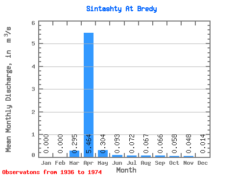
| Statistic | Jan | Feb | Mar | Apr | May | Jun | Jul | Aug | Sep | Oct | Nov | Dec | Annual |
|---|---|---|---|---|---|---|---|---|---|---|---|---|---|
| Mean | 0.00 | 0.00 | 0.29 | 5.46 | 0.30 | 0.09 | 0.07 | 0.07 | 0.07 | 0.06 | 0.05 | 0.01 | 0.60 |
| Standard Deviation | 0.00 | 0.00 | 0.87 | 4.60 | 0.23 | 0.08 | 0.06 | 0.13 | 0.11 | 0.04 | 0.05 | 0.03 | 0.44 |
| Min | 0.00 | 0.00 | 0.00 | 0.75 | 0.04 | 0.00 | 0.01 | 0.00 | 0.00 | 0.00 | 0.00 | 0.00 | 0.11 |
| Max | 0.00 | 0.00 | 3.43 | 14.30 | 0.69 | 0.24 | 0.18 | 0.54 | 0.47 | 0.14 | 0.15 | 0.08 | 1.39 |
| Coefficient of Variation | 2.94 | 0.84 | 0.76 | 0.81 | 0.83 | 1.99 | 1.72 | 0.65 | 1.12 | 1.82 | 0.74 |
 Return to R-Arctic Net Home Page