|
|
|||||||||||||||||
| Point ID: 8758 | Downloads | Plots | Site Data | Code: 12029 |
|
|
|||||||||||||||||
| Download | |
|---|---|
| Site Descriptor Information | Site Time Series Data |
| Link to all available data | |
| View: | Time Series | All |
| Units: | m3/s |
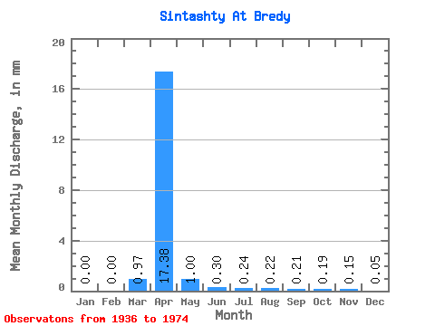
| Statistic | Jan | Feb | Mar | Apr | May | Jun | Jul | Aug | Sep | Oct | Nov | Dec | Annual |
|---|---|---|---|---|---|---|---|---|---|---|---|---|---|
| Mean | 0.00 | 0.00 | 0.97 | 17.38 | 1.00 | 0.30 | 0.24 | 0.22 | 0.21 | 0.19 | 0.15 | 0.05 | 23.12 |
| Standard Deviation | 0.00 | 0.00 | 2.85 | 14.62 | 0.76 | 0.24 | 0.20 | 0.44 | 0.36 | 0.12 | 0.17 | 0.09 | 17.09 |
| Min | 0.00 | 0.00 | 0.00 | 2.38 | 0.12 | 0.00 | 0.02 | 0.01 | 0.00 | 0.00 | 0.00 | 0.00 | 4.13 |
| Max | 0.00 | 0.00 | 11.27 | 45.48 | 2.27 | 0.76 | 0.59 | 1.77 | 1.50 | 0.46 | 0.48 | 0.26 | 53.73 |
| Coefficient of Variation | 2.94 | 0.84 | 0.76 | 0.81 | 0.83 | 1.99 | 1.72 | 0.65 | 1.12 | 1.82 | 0.74 |
 Return to R-Arctic Net Home Page