|
|
|||||||||||||||||
| Point ID: 8738 | Downloads | Plots | Site Data | Code: 12623 |
|
|
|||||||||||||||||
| Download | |
|---|---|
| Site Descriptor Information | Site Time Series Data |
| Link to all available data | |
| View: | Time Series | All |
| Units: | mm |
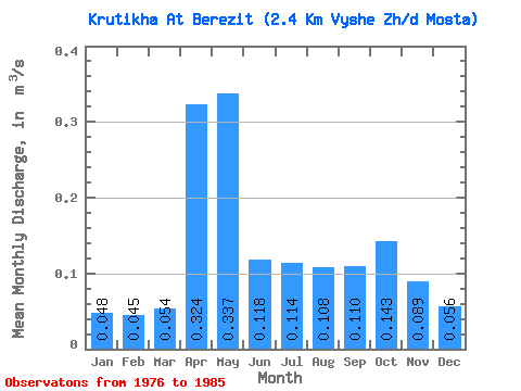
| Statistic | Jan | Feb | Mar | Apr | May | Jun | Jul | Aug | Sep | Oct | Nov | Dec | Annual |
|---|---|---|---|---|---|---|---|---|---|---|---|---|---|
| Mean | 0.05 | 0.04 | 0.05 | 0.32 | 0.34 | 0.12 | 0.11 | 0.11 | 0.11 | 0.14 | 0.09 | 0.06 | 0.13 |
| Standard Deviation | 0.03 | 0.03 | 0.04 | 0.26 | 0.36 | 0.07 | 0.09 | 0.13 | 0.10 | 0.12 | 0.08 | 0.03 | 0.07 |
| Min | 0.02 | 0.02 | 0.02 | 0.05 | 0.07 | 0.03 | 0.02 | 0.01 | 0.01 | 0.01 | 0.02 | 0.01 | 0.04 |
| Max | 0.10 | 0.10 | 0.13 | 0.74 | 1.22 | 0.23 | 0.28 | 0.44 | 0.30 | 0.42 | 0.28 | 0.11 | 0.23 |
| Coefficient of Variation | 0.64 | 0.60 | 0.68 | 0.79 | 1.06 | 0.59 | 0.75 | 1.16 | 0.89 | 0.85 | 0.88 | 0.61 | 0.52 |
 Return to R-Arctic Net Home Page