|
|
|||||||||||||||||
| Point ID: 8738 | Downloads | Plots | Site Data | Code: 12623 |
|
|
|||||||||||||||||
| Download | |
|---|---|
| Site Descriptor Information | Site Time Series Data |
| Link to all available data | |
| View: | Time Series | All |
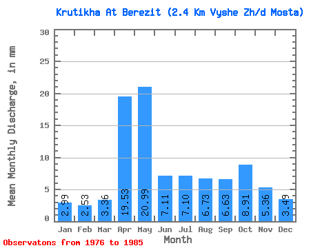
| Units: | m3/s |
| Statistic | Jan | Feb | Mar | Apr | May | Jun | Jul | Aug | Sep | Oct | Nov | Dec | Annual |
|---|---|---|---|---|---|---|---|---|---|---|---|---|---|
| Mean | 3.01 | 2.54 | 3.37 | 19.55 | 20.96 | 7.11 | 7.09 | 6.75 | 6.61 | 8.89 | 5.34 | 3.50 | 98.63 |
| Standard Deviation | 1.92 | 1.54 | 2.29 | 15.35 | 22.29 | 4.18 | 5.30 | 7.82 | 5.88 | 7.59 | 4.67 | 2.13 | 51.45 |
| Min | 1.06 | 1.05 | 1.16 | 3.01 | 4.17 | 1.69 | 1.06 | 0.72 | 0.64 | 0.93 | 1.02 | 0.93 | 27.03 |
| Max | 6.04 | 5.67 | 8.10 | 44.61 | 75.98 | 13.86 | 17.50 | 27.40 | 18.08 | 26.16 | 16.88 | 6.85 | 171.87 |
| Coefficient of Variation | 0.64 | 0.60 | 0.68 | 0.79 | 1.06 | 0.59 | 0.75 | 1.16 | 0.89 | 0.85 | 0.88 | 0.61 | 0.52 |
 Return to R-Arctic Net Home Page