|
|
|||||||||||||||||
| Point ID: 8702 | Downloads | Plots | Site Data | Code: 11634 |
|
|
|||||||||||||||||
| Download | |
|---|---|
| Site Descriptor Information | Site Time Series Data |
| Link to all available data | |
| View: | Time Series | All |
| Units: | mm |
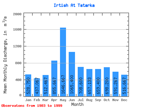
| Statistic | Jan | Feb | Mar | Apr | May | Jun | Jul | Aug | Sep | Oct | Nov | Dec | Annual |
|---|---|---|---|---|---|---|---|---|---|---|---|---|---|
| Mean | 528.75 | 437.07 | 512.47 | 855.67 | 1646.67 | 1065.40 | 708.60 | 657.13 | 659.40 | 698.20 | 591.27 | 516.67 | 761.51 |
| Standard Deviation | 96.52 | 216.54 | 136.28 | 234.26 | 204.82 | 225.13 | 97.64 | 115.06 | 110.11 | 91.17 | 119.86 | 116.11 | 90.23 |
| Min | 361.00 | 46.00 | 237.00 | 529.00 | 1130.00 | 698.00 | 570.00 | 470.00 | 478.00 | 493.00 | 422.00 | 290.00 | 619.75 |
| Max | 695.00 | 712.00 | 761.00 | 1320.00 | 1940.00 | 1470.00 | 882.00 | 893.00 | 826.00 | 843.00 | 913.00 | 713.00 | 906.08 |
| Coefficient of Variation | 0.18 | 0.49 | 0.27 | 0.27 | 0.12 | 0.21 | 0.14 | 0.17 | 0.17 | 0.13 | 0.20 | 0.23 | 0.12 |
 Return to R-Arctic Net Home Page