|
|
|||||||||||||||||
| Point ID: 8670 | Downloads | Plots | Site Data | Code: 11530 |
|
|
|||||||||||||||||
| Download | |
|---|---|
| Site Descriptor Information | Site Time Series Data |
| Link to all available data | |
| View: | Time Series | All |
| Units: | mm |
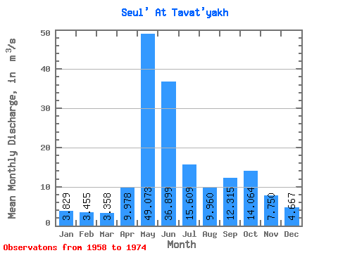
| Statistic | Jan | Feb | Mar | Apr | May | Jun | Jul | Aug | Sep | Oct | Nov | Dec | Annual |
|---|---|---|---|---|---|---|---|---|---|---|---|---|---|
| Mean | 3.83 | 3.46 | 3.36 | 9.98 | 49.07 | 36.90 | 15.61 | 9.96 | 12.31 | 14.06 | 7.75 | 4.67 | 14.40 |
| Standard Deviation | 0.86 | 0.53 | 0.54 | 7.72 | 20.03 | 21.64 | 9.36 | 9.20 | 8.66 | 10.76 | 4.19 | 1.67 | 4.89 |
| Min | 2.70 | 2.40 | 2.17 | 2.79 | 10.80 | 7.38 | 5.08 | 4.42 | 4.92 | 5.87 | 3.89 | 2.97 | 5.30 |
| Max | 5.65 | 4.39 | 4.25 | 31.90 | 91.80 | 85.20 | 35.60 | 40.90 | 38.80 | 47.30 | 17.90 | 8.79 | 22.40 |
| Coefficient of Variation | 0.22 | 0.15 | 0.16 | 0.77 | 0.41 | 0.59 | 0.60 | 0.92 | 0.70 | 0.77 | 0.54 | 0.36 | 0.34 |
 Return to R-Arctic Net Home Page