|
|
|||||||||||||||||
| Point ID: 8670 | Downloads | Plots | Site Data | Code: 11530 |
|
|
|||||||||||||||||
| Download | |
|---|---|
| Site Descriptor Information | Site Time Series Data |
| Link to all available data | |
| View: | Time Series | All |
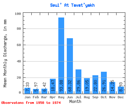
| Units: | m3/s |
| Statistic | Jan | Feb | Mar | Apr | May | Jun | Jul | Aug | Sep | Oct | Nov | Dec | Annual |
|---|---|---|---|---|---|---|---|---|---|---|---|---|---|
| Mean | 7.32 | 6.02 | 6.42 | 18.47 | 93.87 | 68.31 | 29.86 | 19.05 | 22.80 | 26.90 | 14.35 | 8.93 | 324.71 |
| Standard Deviation | 1.64 | 0.93 | 1.04 | 14.29 | 38.32 | 40.06 | 17.91 | 17.60 | 16.03 | 20.57 | 7.75 | 3.19 | 110.30 |
| Min | 5.17 | 4.18 | 4.15 | 5.17 | 20.66 | 13.66 | 9.72 | 8.46 | 9.11 | 11.23 | 7.20 | 5.68 | 119.53 |
| Max | 10.81 | 7.65 | 8.13 | 59.06 | 175.60 | 157.74 | 68.10 | 78.24 | 71.83 | 90.48 | 33.14 | 16.81 | 505.00 |
| Coefficient of Variation | 0.22 | 0.15 | 0.16 | 0.77 | 0.41 | 0.59 | 0.60 | 0.92 | 0.70 | 0.77 | 0.54 | 0.36 | 0.34 |
 Return to R-Arctic Net Home Page