|
|
|||||||||||||||||
| Point ID: 8665 | Downloads | Plots | Site Data | Code: 11507 |
|
|
|||||||||||||||||
| Download | |
|---|---|
| Site Descriptor Information | Site Time Series Data |
| Link to all available data | |
| View: | Time Series | All |
| Units: | mm |
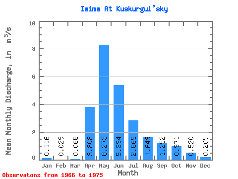
| Statistic | Jan | Feb | Mar | Apr | May | Jun | Jul | Aug | Sep | Oct | Nov | Dec | Annual |
|---|---|---|---|---|---|---|---|---|---|---|---|---|---|
| Mean | 0.12 | 0.03 | 0.07 | 3.81 | 8.27 | 5.39 | 2.87 | 1.65 | 1.25 | 0.97 | 0.52 | 0.21 | 2.07 |
| Standard Deviation | 0.19 | 0.05 | 0.12 | 2.99 | 7.32 | 4.89 | 2.23 | 1.21 | 0.85 | 0.94 | 0.66 | 0.42 | 1.66 |
| Min | 0.00 | 0.00 | 0.00 | 1.07 | 1.66 | 0.73 | 0.12 | 0.06 | 0.04 | 0.01 | 0.00 | 0.00 | 0.35 |
| Max | 0.41 | 0.15 | 0.37 | 9.82 | 20.80 | 14.90 | 6.12 | 3.72 | 2.38 | 3.13 | 2.02 | 1.05 | 4.71 |
| Coefficient of Variation | 1.62 | 1.83 | 1.83 | 0.79 | 0.88 | 0.91 | 0.78 | 0.74 | 0.68 | 0.97 | 1.28 | 2.00 | 0.80 |
 Return to R-Arctic Net Home Page