|
|
|||||||||||||||||
| Point ID: 8665 | Downloads | Plots | Site Data | Code: 11507 |
|
|
|||||||||||||||||
| Download | |
|---|---|
| Site Descriptor Information | Site Time Series Data |
| Link to all available data | |
| View: | Time Series | All |
| Units: | m3/s |
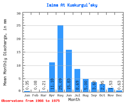
| Statistic | Jan | Feb | Mar | Apr | May | Jun | Jul | Aug | Sep | Oct | Nov | Dec | Annual |
|---|---|---|---|---|---|---|---|---|---|---|---|---|---|
| Mean | 0.35 | 0.08 | 0.21 | 11.18 | 25.09 | 15.84 | 8.69 | 5.00 | 3.67 | 2.94 | 1.52 | 0.63 | 74.09 |
| Standard Deviation | 0.57 | 0.15 | 0.38 | 8.78 | 22.19 | 14.36 | 6.77 | 3.68 | 2.51 | 2.86 | 1.95 | 1.27 | 59.22 |
| Min | 0.00 | 0.00 | 0.00 | 3.14 | 5.04 | 2.14 | 0.37 | 0.19 | 0.11 | 0.03 | 0.00 | 0.00 | 12.66 |
| Max | 1.24 | 0.41 | 1.12 | 28.83 | 63.08 | 43.74 | 18.56 | 11.28 | 6.99 | 9.49 | 5.93 | 3.18 | 168.47 |
| Coefficient of Variation | 1.62 | 1.83 | 1.83 | 0.79 | 0.88 | 0.91 | 0.78 | 0.74 | 0.68 | 0.97 | 1.28 | 2.00 | 0.80 |
 Return to R-Arctic Net Home Page