|
|
|||||||||||||||||
| Point ID: 8662 | Downloads | Plots | Site Data | Code: 11500 |
|
|
|||||||||||||||||
| Download | |
|---|---|
| Site Descriptor Information | Site Time Series Data |
| Link to all available data | |
| View: | Time Series | All |
| Units: | mm |
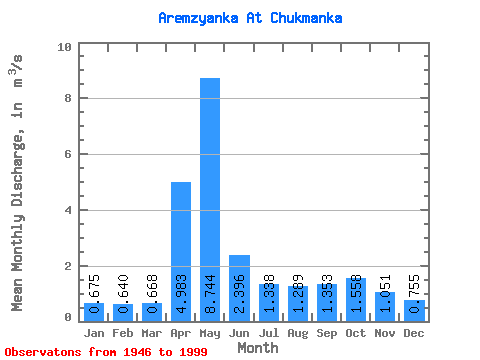
| Statistic | Jan | Feb | Mar | Apr | May | Jun | Jul | Aug | Sep | Oct | Nov | Dec | Annual |
|---|---|---|---|---|---|---|---|---|---|---|---|---|---|
| Mean | 0.68 | 0.64 | 0.67 | 4.98 | 8.74 | 2.40 | 1.34 | 1.29 | 1.35 | 1.56 | 1.05 | 0.76 | 2.10 |
| Standard Deviation | 0.25 | 0.25 | 0.26 | 3.52 | 7.44 | 1.87 | 1.14 | 1.38 | 0.95 | 1.03 | 0.60 | 0.28 | 0.92 |
| Min | 0.25 | 0.21 | 0.23 | 0.60 | 1.20 | 0.48 | 0.37 | 0.34 | 0.39 | 0.42 | 0.29 | 0.25 | 0.72 |
| Max | 1.31 | 1.36 | 1.43 | 16.50 | 32.20 | 8.63 | 6.65 | 7.56 | 5.99 | 5.26 | 3.05 | 1.39 | 4.87 |
| Coefficient of Variation | 0.38 | 0.40 | 0.39 | 0.71 | 0.85 | 0.78 | 0.85 | 1.07 | 0.70 | 0.66 | 0.58 | 0.37 | 0.44 |
 Return to R-Arctic Net Home Page