|
|
|||||||||||||||||
| Point ID: 8662 | Downloads | Plots | Site Data | Code: 11500 |
|
|
|||||||||||||||||
| Download | |
|---|---|
| Site Descriptor Information | Site Time Series Data |
| Link to all available data | |
| View: | Time Series | All |
| Units: | m3/s |
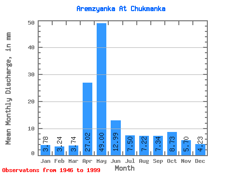
| Statistic | Jan | Feb | Mar | Apr | May | Jun | Jul | Aug | Sep | Oct | Nov | Dec | Annual |
|---|---|---|---|---|---|---|---|---|---|---|---|---|---|
| Mean | 3.78 | 3.27 | 3.74 | 27.02 | 48.99 | 12.99 | 7.50 | 7.22 | 7.34 | 8.73 | 5.70 | 4.23 | 138.31 |
| Standard Deviation | 1.42 | 1.29 | 1.47 | 19.07 | 41.70 | 10.12 | 6.40 | 7.72 | 5.16 | 5.75 | 3.28 | 1.58 | 60.89 |
| Min | 1.40 | 1.07 | 1.29 | 3.25 | 6.72 | 2.60 | 2.07 | 1.91 | 2.12 | 2.35 | 1.57 | 1.40 | 47.37 |
| Max | 7.34 | 6.94 | 8.01 | 89.47 | 180.40 | 46.80 | 37.26 | 42.35 | 32.48 | 29.47 | 16.54 | 7.79 | 321.32 |
| Coefficient of Variation | 0.38 | 0.40 | 0.39 | 0.71 | 0.85 | 0.78 | 0.85 | 1.07 | 0.70 | 0.66 | 0.58 | 0.37 | 0.44 |
 Return to R-Arctic Net Home Page