|
|
|||||||||||||||||
| Point ID: 8653 | Downloads | Plots | Site Data | Code: 11454 |
|
|
|||||||||||||||||
| Download | |
|---|---|
| Site Descriptor Information | Site Time Series Data |
| Link to all available data | |
| View: | Time Series | All |
| Units: | mm |
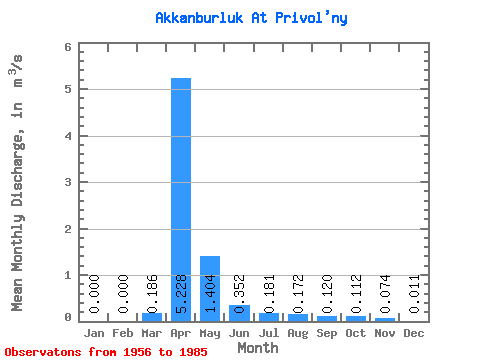
| Statistic | Jan | Feb | Mar | Apr | May | Jun | Jul | Aug | Sep | Oct | Nov | Dec | Annual |
|---|---|---|---|---|---|---|---|---|---|---|---|---|---|
| Mean | 0.00 | 0.00 | 0.19 | 5.23 | 1.40 | 0.35 | 0.18 | 0.17 | 0.12 | 0.11 | 0.07 | 0.01 | 0.64 |
| Standard Deviation | 0.00 | 0.00 | 0.73 | 3.33 | 2.03 | 0.40 | 0.18 | 0.27 | 0.11 | 0.08 | 0.08 | 0.03 | 0.42 |
| Min | 0.00 | 0.00 | 0.00 | 0.38 | 0.11 | 0.01 | 0.00 | 0.00 | 0.00 | 0.00 | 0.00 | 0.00 | 0.07 |
| Max | 0.00 | 0.00 | 3.89 | 15.30 | 9.78 | 1.58 | 0.75 | 1.43 | 0.52 | 0.36 | 0.30 | 0.13 | 1.72 |
| Coefficient of Variation | 3.91 | 0.64 | 1.45 | 1.12 | 1.02 | 1.54 | 0.95 | 0.75 | 1.08 | 2.51 | 0.66 |
 Return to R-Arctic Net Home Page