|
|
|||||||||||||||||
| Point ID: 8653 | Downloads | Plots | Site Data | Code: 11454 |
|
|
|||||||||||||||||
| Download | |
|---|---|
| Site Descriptor Information | Site Time Series Data |
| Link to all available data | |
| View: | Time Series | All |
| Units: | m3/s |
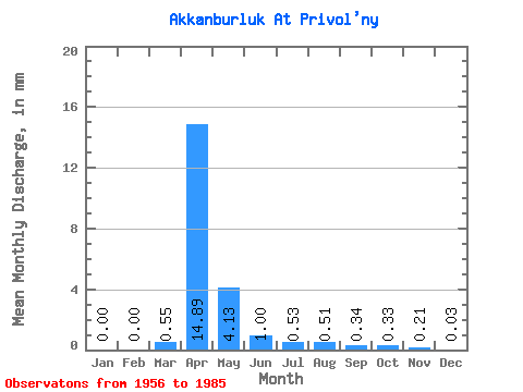
| Statistic | Jan | Feb | Mar | Apr | May | Jun | Jul | Aug | Sep | Oct | Nov | Dec | Annual |
|---|---|---|---|---|---|---|---|---|---|---|---|---|---|
| Mean | 0.00 | 0.00 | 0.55 | 14.89 | 4.13 | 1.00 | 0.53 | 0.51 | 0.34 | 0.33 | 0.21 | 0.03 | 22.20 |
| Standard Deviation | 0.00 | 0.00 | 2.14 | 9.47 | 5.97 | 1.12 | 0.54 | 0.78 | 0.32 | 0.25 | 0.23 | 0.08 | 14.69 |
| Min | 0.00 | 0.00 | 0.00 | 1.08 | 0.32 | 0.04 | 0.00 | 0.00 | 0.00 | 0.00 | 0.00 | 0.00 | 2.30 |
| Max | 0.00 | 0.00 | 11.45 | 43.58 | 28.78 | 4.50 | 2.21 | 4.21 | 1.48 | 1.06 | 0.85 | 0.38 | 59.68 |
| Coefficient of Variation | 3.91 | 0.64 | 1.45 | 1.12 | 1.02 | 1.54 | 0.95 | 0.75 | 1.08 | 2.51 | 0.66 |
 Return to R-Arctic Net Home Page