|
|
|||||||||||||||||
| Point ID: 8638 | Downloads | Plots | Site Data | Code: 11345 |
|
|
|||||||||||||||||
| Download | |
|---|---|
| Site Descriptor Information | Site Time Series Data |
| Link to all available data | |
| View: | Time Series | All |
| Units: | mm |
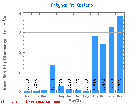
| Statistic | Jan | Feb | Mar | Apr | May | Jun | Jul | Aug | Sep | Oct | Nov | Dec | Annual |
|---|---|---|---|---|---|---|---|---|---|---|---|---|---|
| Mean | 0.09 | 0.09 | 0.13 | 1.39 | 0.37 | 0.18 | 0.14 | 0.10 | 2.82 | 2.44 | 3.28 | 3.79 | 0.23 |
| Standard Deviation | 0.02 | 0.02 | 0.11 | 0.89 | 0.34 | 0.26 | 0.17 | 0.05 | 15.65 | 13.38 | 18.26 | 21.22 | 0.10 |
| Min | 0.06 | 0.06 | 0.07 | 0.34 | 0.07 | 0.02 | 0.02 | 0.02 | 0.03 | 0.01 | 0.05 | 0.05 | 0.09 |
| Max | 0.13 | 0.13 | 0.64 | 3.92 | 1.56 | 1.45 | 1.00 | 0.27 | 90.00 | 77.00 | 105.00 | 122.00 | 0.57 |
| Coefficient of Variation | 0.21 | 0.20 | 0.86 | 0.64 | 0.91 | 1.47 | 1.23 | 0.51 | 5.55 | 5.48 | 5.57 | 5.61 | 0.45 |
 Return to R-Arctic Net Home Page