|
|
|||||||||||||||||
| Point ID: 8638 | Downloads | Plots | Site Data | Code: 11345 |
|
|
|||||||||||||||||
| Download | |
|---|---|
| Site Descriptor Information | Site Time Series Data |
| Link to all available data | |
| View: | Time Series | All |
| Units: | m3/s |
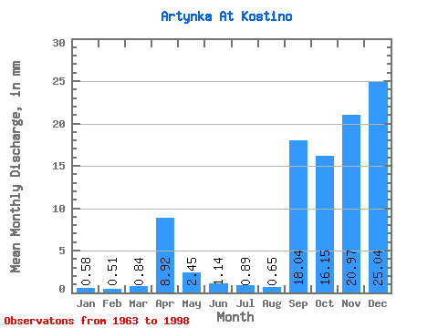
| Statistic | Jan | Feb | Mar | Apr | May | Jun | Jul | Aug | Sep | Oct | Nov | Dec | Annual |
|---|---|---|---|---|---|---|---|---|---|---|---|---|---|
| Mean | 0.58 | 0.52 | 0.84 | 8.91 | 2.45 | 1.14 | 0.89 | 0.66 | 18.04 | 16.15 | 20.97 | 25.03 | 18.31 |
| Standard Deviation | 0.12 | 0.10 | 0.73 | 5.66 | 2.23 | 1.68 | 1.09 | 0.33 | 100.16 | 88.50 | 116.87 | 140.32 | 8.19 |
| Min | 0.40 | 0.37 | 0.46 | 2.18 | 0.44 | 0.11 | 0.16 | 0.14 | 0.20 | 0.10 | 0.33 | 0.34 | 7.21 |
| Max | 0.86 | 0.78 | 4.24 | 25.09 | 10.31 | 9.28 | 6.61 | 1.79 | 576.00 | 509.15 | 672.00 | 806.71 | 44.56 |
| Coefficient of Variation | 0.21 | 0.20 | 0.86 | 0.64 | 0.91 | 1.47 | 1.23 | 0.51 | 5.55 | 5.48 | 5.57 | 5.61 | 0.45 |
 Return to R-Arctic Net Home Page