|
|
|||||||||||||||||
| Point ID: 8633 | Downloads | Plots | Site Data | Code: 11317 |
|
|
|||||||||||||||||
| Download | |
|---|---|
| Site Descriptor Information | Site Time Series Data |
| Link to all available data | |
| View: | Time Series | All |
| Units: | mm |
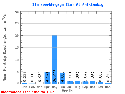
| Statistic | Jan | Feb | Mar | Apr | May | Jun | Jul | Aug | Sep | Oct | Nov | Dec | Annual |
|---|---|---|---|---|---|---|---|---|---|---|---|---|---|
| Mean | 0.23 | 0.11 | 0.08 | 4.94 | 20.01 | 4.69 | 1.30 | 1.36 | 1.05 | 1.27 | 0.80 | 0.34 | 3.35 |
| Standard Deviation | 0.26 | 0.12 | 0.08 | 6.82 | 12.58 | 2.91 | 1.65 | 2.35 | 1.51 | 1.45 | 0.86 | 0.39 | 1.76 |
| Min | 0.01 | 0.00 | 0.00 | 0.55 | 0.59 | 0.41 | 0.16 | 0.07 | 0.07 | 0.07 | 0.06 | 0.01 | 0.31 |
| Max | 0.84 | 0.35 | 0.24 | 22.80 | 40.40 | 9.79 | 5.63 | 8.43 | 5.69 | 5.36 | 3.28 | 1.25 | 6.37 |
| Coefficient of Variation | 1.14 | 1.08 | 0.98 | 1.38 | 0.63 | 0.62 | 1.27 | 1.73 | 1.44 | 1.14 | 1.07 | 1.12 | 0.53 |
 Return to R-Arctic Net Home Page