|
|
|||||||||||||||||
| Point ID: 8633 | Downloads | Plots | Site Data | Code: 11317 |
|
|
|||||||||||||||||
| Download | |
|---|---|
| Site Descriptor Information | Site Time Series Data |
| Link to all available data | |
| View: | Time Series | All |
| Units: | m3/s |
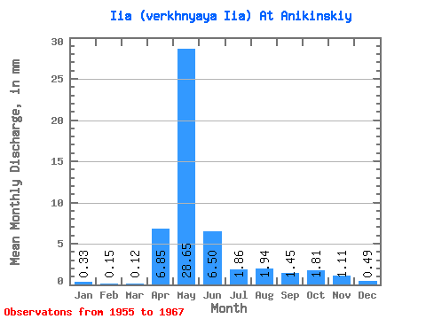
| Statistic | Jan | Feb | Mar | Apr | May | Jun | Jul | Aug | Sep | Oct | Nov | Dec | Annual |
|---|---|---|---|---|---|---|---|---|---|---|---|---|---|
| Mean | 0.33 | 0.15 | 0.12 | 6.85 | 28.65 | 6.50 | 1.86 | 1.94 | 1.45 | 1.81 | 1.11 | 0.49 | 56.49 |
| Standard Deviation | 0.38 | 0.16 | 0.12 | 9.45 | 18.02 | 4.04 | 2.36 | 3.36 | 2.09 | 2.08 | 1.19 | 0.55 | 29.69 |
| Min | 0.02 | 0.00 | 0.00 | 0.76 | 0.84 | 0.57 | 0.23 | 0.11 | 0.09 | 0.11 | 0.08 | 0.01 | 5.18 |
| Max | 1.20 | 0.46 | 0.34 | 31.60 | 57.86 | 13.57 | 8.06 | 12.07 | 7.89 | 7.68 | 4.55 | 1.79 | 107.44 |
| Coefficient of Variation | 1.14 | 1.08 | 0.98 | 1.38 | 0.63 | 0.62 | 1.27 | 1.73 | 1.44 | 1.14 | 1.07 | 1.12 | 0.53 |
 Return to R-Arctic Net Home Page