|
|
|||||||||||||||||
| Point ID: 8619 | Downloads | Plots | Site Data | Code: 11245 |
|
|
|||||||||||||||||
| Download | |
|---|---|
| Site Descriptor Information | Site Time Series Data |
| Link to all available data | |
| View: | Time Series | All |
| Units: | mm |
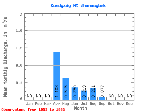
| Statistic | Jan | Feb | Mar | Apr | May | Jun | Jul | Aug | Sep | Oct | Nov | Dec | Annual |
|---|---|---|---|---|---|---|---|---|---|---|---|---|---|
| Mean | 1.10 | 0.52 | 0.29 | 0.22 | 0.28 | 0.08 | |||||||
| Standard Deviation | 0.92 | 0.52 | 0.31 | 0.23 | |||||||||
| Min | 0.32 | 0.05 | 0.04 | 0.07 | 0.28 | 0.08 | |||||||
| Max | 2.44 | 1.56 | 0.88 | 0.56 | 0.28 | 0.08 | |||||||
| Coefficient of Variation | 0.84 | 1.00 | 1.07 | 1.05 |
 Return to R-Arctic Net Home Page